After starting the week with rather mild weather, the next bout of snow arrives mid-week, with the bulk of the snow hitting the high-country late Wednesday and Thursday. The mountains of the Snowy Range and Sierra Madres should do very well with this system, dropping 12 to 18 inches of snow by Thursday at the highest elevations. Elsewhere, snowfall should be light, but flurries are possible. A slow warming trend arrives heading into the weekend. Expect breezes, but mostly clear skies.
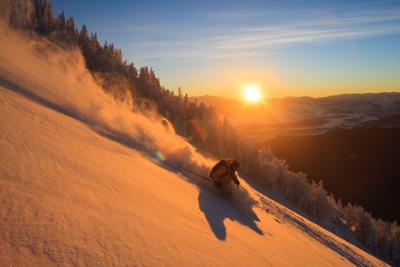
The Snowy Range Ski and Recreation Area issued powder alerts last Friday and Saturday with a total of 16 inches of new snow blanketing the slopes in just those two days. A skier said the conditions Saturday morning were amazing, and the best conditions of the year. Snow is in the forecast Thursday, but amounts are forecast to be closer to 3-5 inches. Skies clear for the weekend, although breezes pick up.
Snow arrived in earnest this past week in northwest Wyoming. At Grand Targhee 27 inches fell Friday and Saturday. At Jackson Hole Mountain Resort the snow also dumped, delivering 35 inches in those two days. The big blast increased the snowpack there to 87% of average.
To the south in Colorado, Steamboat continued to come out the winner with skiers and snowboarders enjoying 17 inches of new powder late last week and into the weekend. That area has a snowpack depth at 105% of normal.
Skiers and riders at Winter Park enjoyed 20 inches of new snow over the weekend, upping the snowpack there to 108% of normal. The next bout of snow is modest by comparison, with eight inches in the forecast through the weekend into early next week.
Personnel at the Colorado Avalanche Information Center report the avalanche danger for the southern Wyoming and northern Colorado mountains is rated “considerable” above and near treeline and “moderate” below treeline. Strong winds create cohesive slabs with wind-drifted snow over weak layers buried deeper in the snowpack. Instability in both the Sierra Madre and Snowy Range were reported last weekend on the Eastern Wyoming Avalanche Information Exchange. One report described three slides in the Snowy Range, likely naturally triggered.
At Keystone, near Rob Roy Reservoir, there has been a total of 139 inches of snow so far this season, according to Don Day Jr. at dayweather.com. This is a 24-inch increase from last week, but still well below the 171 inches reported by this time last year. According to Open Snow, the snowpack in the Snowy Range is 85% of average for this time of year, an increase of six percentage points from last week.
Conditions “up top” in the Snowy Range are very good with plenty of powder beckoning. Snow is in the forecast the next couple days before clearing into the weekend. Winds pick up, especially Saturday.
Backcountry skiers report excellent conditions on all trails accessed via Highway 130. Skiers on the Barber Lake Trail reported 18 inches of new snow by the end of last weekend. Snowshoers reported very good conditions with deep snow on the Little Laramie area trails.
Conditions are quite good at Chimney Park and along the Medicine Bow Rail Trail. As of Tuesday morning, there was no recent grooming since early in the month. Expect user-packed conditions for both those on skis and snowshoes.
Conditions on the Nordic ski trails at the Happy Jack Recreation Area are very good to excellent with about six inches of new snow last weekend. Wind action creates some drifted areas, but coverage is good and daily grooming continues. The Tie City trailhead will be busy again Sunday with the final session of the Wee Ski and Kid Ski programs. Expect crowded conditions there from 1-3:30 p.m. at the parking lot and the close-in trails.
The multi-use trails are also packed and in great condition for those running on foot, fat biking and snowshoeing. Be mindful if your travel creates ruts or divots when conditions are especially soft. Those on fat bikes should adjust their air pressure accordingly.
As of Tuesday morning, the U.S. Natural Resources Conservation Service snow measuring stations reports 51 inches of snow at Cinnabar Park, an increase of 11 inches from last week. The station at Brooklyn Lake reports 63 inches, an increase of 18 inches from last week. The report at Sand Lake on the north end of the Medicine Bow Mountains reports 72 inches, an increase of 15 inches from last week. The measuring station at Medicine Bow Peak, at an elevation of 10,500 feet, reports 95 inches, an increase of 24 inches from last week. The Crow Creek station on Pole Mountain shows 15 inches, an increase of two inches from last week.
Cross-country skiing
Pole Mountain/Happy Jack Recreation Area Nordic ski trails: Conditions on the Nordic trails are excellent for good for both classic and skate ski techniques. Daily grooming is underway.
Pole Mountain/Happy Jack Recreation Area Multi-use trails: Conditions are very good with packing for runners, fat bikers, and snowshoers. Expect soft conditions in some stretches.
Chimney Park Nordic ski trails: The trails are in very good conditions, and user-packed. There’s been no recent grooming as of Tuesday morning.
Snowy Range backcountry conditions: Excellent conditions with deep snow. Trails are all user-packed and suitable for skiers and snowshoers.
Snowmobile conditions
Snowy Range: Conditions are excellent up high, but be aware of instability and avoid steep areas where the new snow is more prone to slides.
Quick Numbers
Wyoming downhill areas
Snowy Range Ski Area: 46-inch base; 5 lifts, 33 trails and 100% of terrain open.
Antelope Butte: 16-inch base; no additional information available.
Grand Targhee: 97-inch base; 6 lifts, 89 trails and 94% of terrain open.
Hogadon: 55-inch base; 2 lifts, 28 trails and 100% of terrain open.
Jackson Hole Mountain Resort: 98-inch base; 13 lifts, 125 trails and 95% of terrain open.
Meadowlark Ski Area: 26-inch base; 2 lifts, 12 trails and 86% of terrain open.
Sleeping Giant: Closed this season.
Snow King: 49-inch base; 8 lifts, 41 trails and 87% of terrain open.
White Pine: 22-inch base; 2 lifts, 22 trails and 76% of terrain open.
Colorado downhill areas
Arapahoe Basin: 54-inch base; 9 lifts, 133 trails and 92% of terrain open.
Breckenridge: 56-inch base; 33 lifts, 187 trails and 100% of terrain open.
Copper Mountain: 59-inch base; 23 lifts, 155 trails and 100% of terrain open.
Eldora: 31-inch base; 10 lifts, 64 trails and 98% of terrain open.
Keystone: 51-inch base; 21 lifts, 140 trails and 100% of terrain open.
Loveland: 55-inch base; 10 lifts, 93 trails and 99% of terrain open.
Steamboat: 98-inch base; 23 lifts, 181 trails and 100% of terrain open.
Vail: 62-inch base; 33 lifts, 275 trails and 100% of terrain open.
Winter Park: 72-inch base; 19 lifts, 167 trails and 99% of terrain open.
Let the news come to you
Get any of our free email newsletters — news headlines, sports, arts & entertainment, state legislature, CFD news, and more.